Crystal Kersey, MSc Physical Geography, Project Assistant for the Adaptation and Resilience Training Program (ART) at The Athabasca Watershed Council
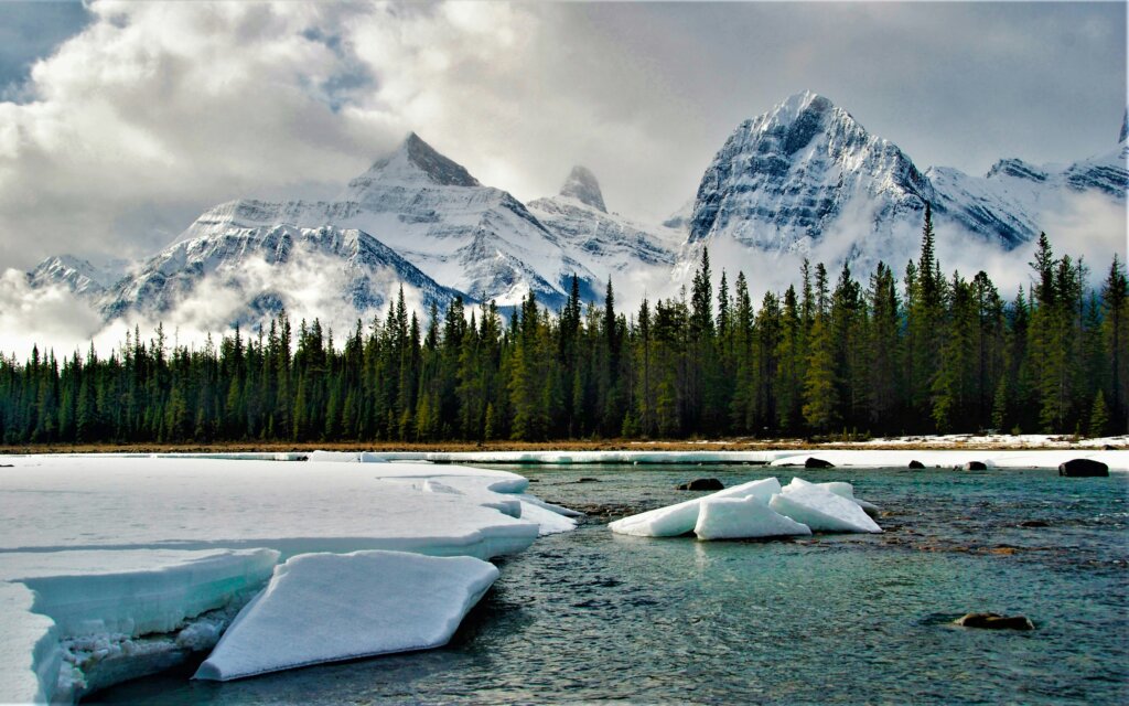
The Athabasca Headwaters play a crucial role in supplying water to downstream ecosystems and communities. Research shows that precipitation is the primary driver of yearly water availability in the Upper Athabasca Watershed, with most of it falling as snow in the headwaters (Newton & Taube, 2023) but snow is not the same across the watershed. Not only does snow not fall uniformly, but also not all snowfall is equal—its water content can vary significantly based on atmospheric conditions. Imagine shovelling a meter of snow when the temperature is -2 versus when the temperature is -20, one is a lot more tiring.
Once on the ground, snow undergoes changes in density due to factors like compaction, partial melting, and wind redistribution. This means that snow depth alone does not directly indicate how much water is stored within the snowpack. At Sunwapta Falls, for instance, snow densities have been recorded between 123 and 398 kg of water per cubic meter of snow (Vionnet 2025). The most common metric to measure water availability from snowpack is called snow water equivalent (SWE). SWE is the amount of liquid water contained in a given volume of snow if it were melted (Avalanche.org, nd.). It is typically expressed in millimeters (mm) or inches and represents the depth of water that would result from the snowpack’s complete melt. The formula for SWE is simple:
SWE= snow depth × snow density
where snow density is the ratio of the mass of snow to the mass of an equal volume of water.
Snow Density: A Key Challenge
Snow density varies both across locations and over time, but our knowledge of the amount of variation in the upper watershed is minimal. Much of the data comes from manual surveys conducted only a few times per year at a handful of sites. The snow is cored and then weighed to ascertain the total water content. In the Athabasca Headwaters, this data is especially scarce—only three locations are monitored, compared to over 20 sites in the Upper Bow River (Vionnet, 2025).
One way to think about snow accumulation in the mountains is as a bank account: snowfall events act as deposits, and meltwater as withdrawals. However, different areas receive varying amounts of deposits, and additional “hidden fees” like sublimation and wind redistribution further complicate the balance. This makes it difficult to determine exactly how much water will be available during the warmer months—an important consideration for communities and industries that rely on this resource.
Measuring Snow Depth in the Headwaters
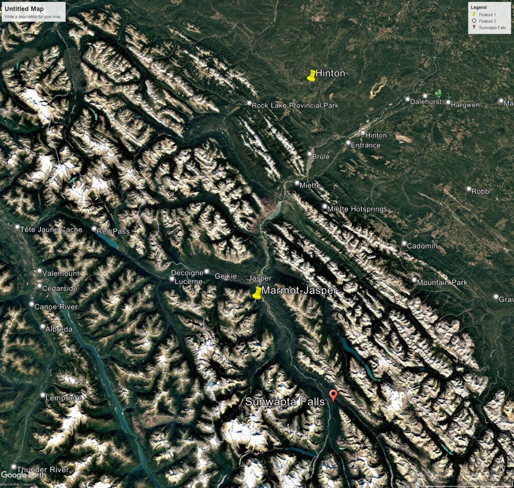
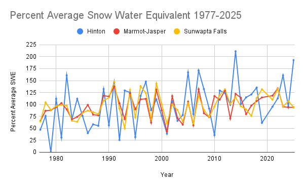
There are three primary locations where snow depth is measured in the Athabasca Headwaters—one near the Marmot Basin Ski Area, one near Sunwapta Falls and one near Hinton. Given that the Marmot site is 430 meters higher in elevation than Sunwapta (1830 m vs. 1400 m), differences in snow depth are expected. On average, February’s snow water equivalent (SWE) at Marmot is 25 mm higher than at Sunwapta Falls. However, this difference isn’t always consistent; in some years, Sunwapta Falls’ SWE has matched or even exceeded that of Marmot Basin. The April 2025 measurements found that the SWE at both Sunwapta Falls and Marmot-Jasper were 94% of average though they varied earlier in the season when SWE was 66% of the February average for Marmot and 53% of the February average for Sunwapta Falls (Alberta Environment and Parks, 2025).

Advancing Snow Monitoring
The only snow data available for the Athabasca headwaters comes from manual measurements, severely limiting our understanding of snow distribution and water availability; however, there are other technologies that can enhance our understanding. Snow pillows are commonly used throughout BC and in some locations in southern Alberta. A snow pillow is a flat pad that weighs the snow and measures the snow depth with a sensor. Both of these signals are then transmitted with onsite telemetry equipment multiple times a day. This type of equipment gives a much more dynamic understanding of snow conditions.

To further improve snowpack monitoring, some organizations are turning to remote sensing technologies. Chris Hopkinson’s lab at The University of Lethbridge conducts LiDAR surveys to measure snow depth over large areas in Southern Alberta. LiDAR works by emitting laser pulses toward a target surface and measuring the time it takes for the light to bounce back to the sensor. By calculating this time delay and combining it with GPS and inertial measurement data, LiDAR creates precise, three-dimensional models of landscapes, buildings, or objects. By comparing ground height measurements from summer to those taken in winter, researchers can estimate snow depth more accurately. When combined with snow density data, these measurements provide a clearer picture of how much water is stored in the mountains, enhancing our ability to predict water availability for the seasons ahead. A LiDAR survey was conducted as far north as Saskatchewan Crossing in 2024 due to concerns about likely drought conditions (UNews, 2024).
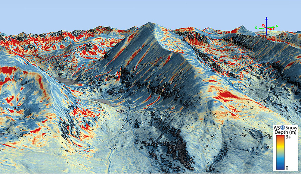
Understanding snowpack dynamics is critical for effective water management in the Athabasca Watershed, where snowmelt contributes significantly to annual streamflow and ecosystem health. In the steep and rugged terrain of the headwaters, remote sensing technologies provide valuable advances in our ability to monitor snowpack conditions. LiDAR technology offers a valuable tool for mapping snow depth across large areas with high spatial resolution, enhancing our ability to track changes in snow accumulation over time. However, LiDAR alone cannot provide a complete picture, as it does not measure snow density—an essential variable for calculating snow water equivalent (SWE), which determines the actual volume of water stored in the snowpack. Therefore, ground-based snow surveys remain necessary to supplement remote sensing data, providing accurate density measurements that can be used to calibrate and validate LiDAR-derived models. The more data points we collect—both for snow depth and snow density—the more accurately we can assess water availability, forecast spring runoff, and support decision-making for water allocation, ecosystem protection, and climate adaptation planning in the region. Expanding the spatial and temporal coverage of both data types will strengthen our understanding of snowpack processes and enhance resilience to future hydrological changes.
References
Automated Snow Monitoring. (n.d.). Retrieved March 3, 2025, from https://www.nrcs.usda.gov/wps/portal/wcc/home/aboutUs/monitoringPrograms/automatedSnowMonitoring/
Avalanche.org » Snow Water Equivalent (SWE). (n.d.). Avalanche.Org. Retrieved March 3, 2025, from https://avalanche.org/avalanche-encyclopedia/snowpack/snowpack-observations/signs-of-instability-red-flags/heavy-snowfall-or-rain/loading-loading-rate/snow-water-equivalent-swe/
Natural Resources Conservation Service (NRCS). (n.d.). Automated Snow Monitoring. Retrieved March 3, 2025, from https://www.nrcs.usda.gov/wps/portal/wcc/home/aboutUs/monitoringPrograms/automatedSnowMonitoring/
NASA Spinoff. (2022, February 28). Getting Water out of Snow with NASA Technology | NASA Spinoff. NASA Spinoff. https://spinoff.nasa.gov/Getting-Water-Out-of-Snow-with-NASA-Technology
Newton, B. W., & Taube, N. (2023). Regional variability and changing water distributions drive large-scale water resource availability in Alberta, Canada. Canadian Water Resources Journal / Revue Canadienne Des Ressources Hydriques, 48(3), 300–326. https://doi.org/10.1080/07011784.2023.2186270
Alberta Environment and Parks. (2025, May 1). [dataset] Alberta Environment and Parks—Alberta River Basins flood alerting, advisories, reporting and water management [Interactive GIS]. Government of Alberta. https://rivers.alberta.ca/#
UNews. (2024, May 8). Measuring the snowpack—University of Lethbridge partners with Alberta Environment and Protected Areas | UNews. https://www.ulethbridge.ca/unews/article/measuring-snowpack-%E2%80%94-university-lethbridge-partners-alberta-environment-and-protected-areas
Vionnet, V., Mortimer, C., Brady, M., Arnal, L., & Brown, R. (2025). Canadian historical Snow Water Equivalent dataset (CanSWE, 1928-2025) (Version v7) [Dataset]. Zenodo. https://doi.org/10.5281/zenodo.14901399