fbpx

The Athabasca Watershed

What is a watershed?

The Athabasca watershed plays a vital role in sustaining our communities and our economy. Protecting and preserving it is a shared responsibility for us all.
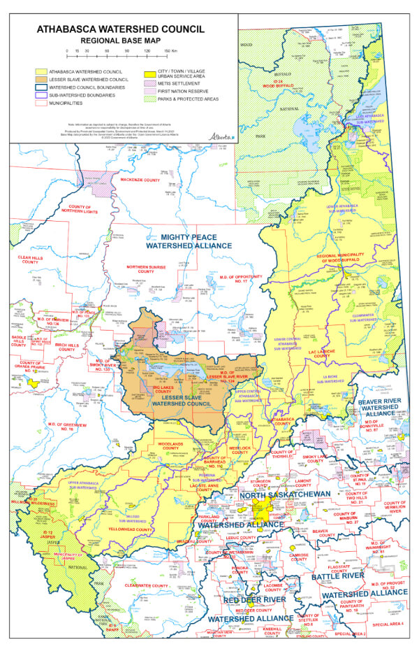
The Athabasca Watershed Council (AWC) is a Watershed Planning and Advisory Council (WPAC). We are working in partnership with the Government of Alberta, Indigenous peoples and other stakeholders, to achieve the three goals of the Water For Life strategy. 
Play Video
A watershed is an area of land that collects and holds water, eventually draining it into a larger body of water such as a lake, river, or ocean. Essentially, everyone lives in a watershed, although these areas are sometimes referred to as basins.

Major River Basins in Alberta

In Alberta, there are seven major river basins or watersheds:
These river basins are essential resources, providing drinking water, supporting industries, and offering recreational opportunities. Every action we take on the landscape impacts these vital water bodies.

Watershed Boundaries

The boundaries of a watershed are defined by the topography of the landscape. Natural dividers such as mountains or ridges (like the Rockies) determine these boundaries. For example, the Continental Divide is a significant ridge that separates river systems flowing west into the Pacific Ocean from those flowing east into the Atlantic or Arctic Oceans.
Water is everywhere. It’s in lakes, sloughs, and puddles. It’s in rivers, creeks, streams, and underground aquifers. It comes from rain, snow, hail, and melting glaciers. All water flows downhill, and if that water eventually ends up in the Athabasca River, then it’s in our watershed.

The Athabasca Watershed

The Athabasca River is approximately 1,231 km long, originating from the Columbia Icefield in Jasper National Park and flowing through the Foothills, Boreal Forest, and Canadian Shield to Lake Athabasca. This journey marks an elevation change from 3,747 to 208 meters. From Lake Athabasca, the waters flow northwest through the Peace/Slave/Mackenzie River system to the Arctic Ocean.

Annual Discharge of the Athabasca River

The mean annual discharge of the Athabasca River is measured at three locations, recorded in cubic decimeters (1 dam³ = 1,000 cubic meters):

Indigenous Territories and Major Tributaries

The watershed spans portions of Treaty 6, Treaty 8, and Treaty 10 territories and is home to many Indigenous peoples. Major tributaries include the Pembina, McLeod, Lesser Slave, Lac La Biche, and Clearwater rivers. The region also contains working landscapes supporting agriculture, forestry, oil and gas, recreation, and more.

Our Collective Responsibility

To manage the water we depend on, we must manage the land we share. This requires coming together to understand the issues, challenges, and opportunities affecting our watershed. The Athabasca Watershed Council works to unite stakeholders, citizens, and Indigenous peoples in the effective management of the Athabasca River Watershed.

The Athabasca Watershed Council: Regional Base Map

Why Watersheds for Water Management?

Watershed management is the study of the relevant characteristics of a watershed aimed at the sustainable distribution of its resources and the process of creating and implementing plans, programs, and projects to sustain and enhance watershed functions that affect the plant, animal, and human communities within the watershed boundary.
Adopting a watershed approach is founded on the basis that Alberta’s water resources must be managed within the capacity of individual watersheds and that all Albertans recognize there are limits to the available water supply. 
What happens on the land and water in a watershed can affect the water supply that rivers, lakes and groundwater provide. While land and water are closely linked, these resources have not historically been managed in a fully integrated manner. Focusing efforts at the watershed level provides a comprehensive understanding of local management needs, and encourages locally-led management decisions.